MAX Wide, US W. Coast & Hawaii, C-Card
MAX Wide
- US W
- Coast & Hawaii
- C-Card
- MFG# NA-M024-C
- vector charts with dynamic nav-aids
- tides & currents
- Guardian Alarm
- port photos and detailed info
- route check
- depths
- land elevations
- perspective view
- and points of interest
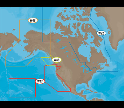
- Map area: W47
- US W
- Coast & Hawaii
- C-Card
- MFG# NA-M024-C
- vector charts with dynamic nav-aids
- tides & currents
- Guardian Alarm
- port photos and detailed info
- route check
- depths
- land elevations
- perspective view
- and points of interest
- Map area: W47